
Research of Shopping Center Renovations
Church Renovations post Vatican II
Church Building examples and resources
San Fernando Valley Low-Rise Commercial Building Visual Survey
American Institute of Architects - San Fernando Valley Chapter - Urban Design Assistance Team - Panorama City, California
Urban Design Assistance Team - Panorama Commercial District
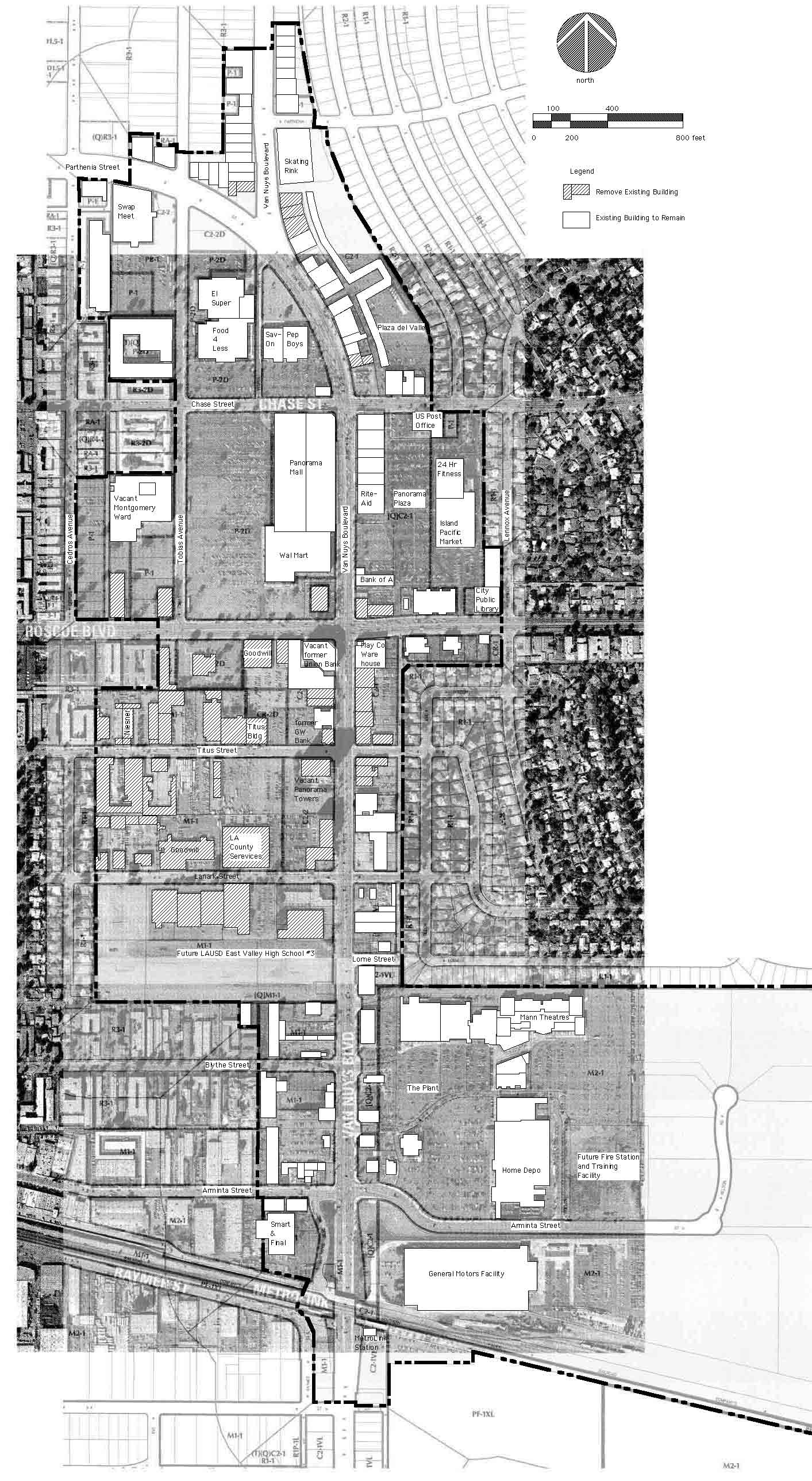
The Panorama City UDAT study area is defined by the areas included in the Los Angeles City Planning Panorama Community Design Overlay which range from Parthenia Street on the northern edge to the Metrolink at Keswick Street on the southern edge. Van Nuys Boulevard is the major north-south collector. Roscoe Boulevard is the major east-west traffic arterial.
 panoramaaerial.jpg |
Goals and Objectives of the Panorama City UDAT - within the context of City of Los Angeles General Plan Framework (adopted in 1993 and affirmed in 2001) are: 1) to erase blight, develop underutilizied land, increase building occupancy, create jobs and economic opportunities; 2) to protect single family neighbohoods; 3) to direct new housing along transit corridors; 4) to create pedestrian-friendly, mixed-use neighborhood districts and 5) to focus urban development to neglected in-fill areas - mitigating the sprawl which consumes greenbelt agricultural property at the city limits. Scheme A consists of a collaborative design effort by UDAT members Larry Robbins, Tom Rath, Jerry Pollak, and Paul LIndblad in March 2003. Paul Lindblad sketched Scheme 'A' pictured here. Existing Inventory Map Los Angeles City Planning Department provided the aerial photo showing existing properties with actual building improvements and the Panorama City Community Design Overlay (CDO) maps of property zoning information. The black and white aerial photo was superimposed over the zoning information and yields a comprehensive depiction of each commercial property as defined by the Panorama City Urban Design assistance Team (UDAT) Study Area (which corresponds to the CDO boundaries). North is toward the top of this view. You may view this map/aerial composite (scaled accurately to 1" = 200') which can be printed at this scale. A color rendition of an aerial photo of the 280.8 acre, 1.33 mile long CDO commercial district of Panorama City may be viewed here. The larger context showing the extents of the Panorama City Neighborhood Council (depicting the CDO commercial district) may be viewed here. Panorama North Commercial District existing locations (pictured here) range from Parthenia Street on the northern edge to the southern edge (Chase Street). Panorama Central Commercial District existing locations (pictured here) range from the northern edge (Chase Street) to the southern edge (Lanark Street). Panorama South Commercial District existing locations (pictured here) range from Lanark Street on the northern edge to the Metrolink at the southern edge (Keswick Street). |
Last
Updated 04-27-2009
Copyright © 1998-2020 Lindblad Architects - All Rights Reserved